
Maps have numbered vertical and horizontal grid lines that enable the reader to identify and communicate a particular location on the map. The vertical lines are aligned with grid north, and the horizontal ones are exactly perpendicular to the vertical lines.
The Universal Transverse Mercator (UTM) system, which describes a point in terms of metres, is most commonly used by modern topographic maps. And this is the system described here.
In the UTM system, the vertical lines are called Eastings (i.e. they help locate how far east the point is), and the horizontal lines are called Northings (i.e. they establish how far north the point is). Most maps also include the Longitude and Latitude of the map at the corners (i.e. a reading in degrees, minutes and seconds).
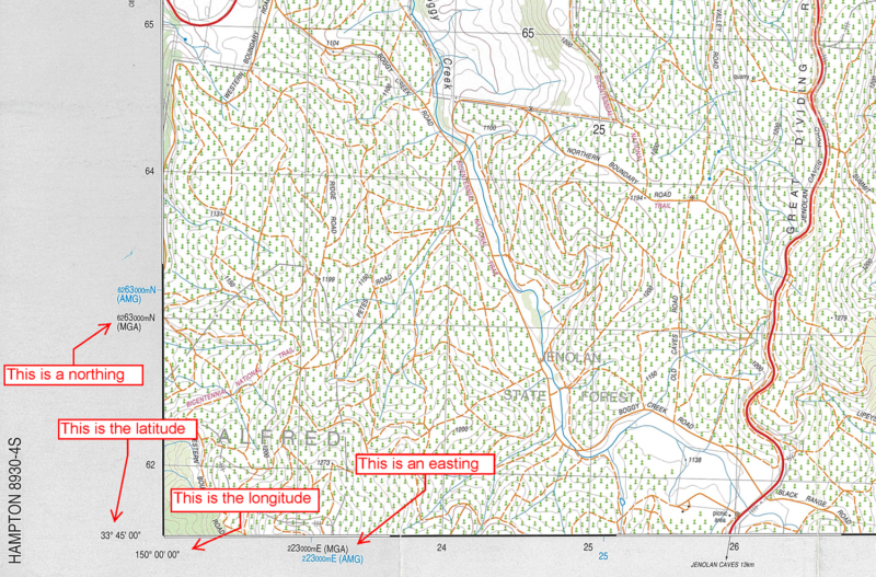
A UTM grid reference tells the reader how East and how far North to go on the map. It consists of two parts – the Easting digits, and the Northing digits – and always has an even number of digits. Determine the number of Eastings and Northings digits by dividing the whole grid coordinate by 2. The more digits, the more accurate the grid reference.
When reading a grid reference, Eastings always come first, followed by the Northings. A simple way to remember this is the saying ‘cross the creek before going up the tree’, that is, go horizontal first, then vertical.
Example 1: Describing the location of the hill labelled 619. The 619 refers to the height of the hill in metres. Often, bushwalkers describe a hill by its height, unless another name is written on the map (typical for popular and distinctive hills). In this example, since the hill has no name it can be called Hill 619.
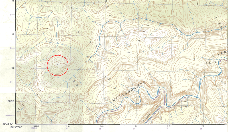
On the 1:25,000 map above, each square is 1km wide and high. The Northing and Easting lines are all numbered. Ignoring the small numbers either side of the black numbers (explained later), notice that the lines increase by one unit along the bottom (68, 69, 70, 71…) and up the left-hand side of the map (05, 06, 07, 08…).
A four digit grid reference (2 digits for the Easting, and 2 for the Northing) is a crude measure of the location with an accuracy of one square kilometre. It describes the intersection of two lines. The closest intersection to Hill 619 is the intersections of the Easting line 69 with the Northing line 06. Hence Hill 619 has a four digit coordinate of 6906 plotted as a white circle below.
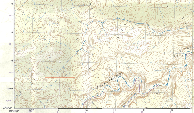
However, since the margin of error in a four digit this grid coordinate is 1km square (outlined in orange), this reference could describe any of the features from the hill in question, to a gully or a creek junction. To more accurately describe Hill 619, it’s best to use a six-digit grid reference.
Draw perpendicular lines from Hill 619 to intersect with the Easting and Northing lines. Then measure how far along the grid the lines are. For the Easting, the line crosses 6/10th of the way along the grid. Hence the Easting coordinate is 686. For the Northing, the line intersects 1/10th of the way up. Hence the Northing coordinate is 061. The Hill has a six-digit grid reference of 686061. Since the map is an old map (‘1:25,000 Colo Heights’) and uses the AMG reference system, the six-digit grid reference is ‘Colo Heights AMG-686061’.
A six figure coordinate has six figure grid reference an accuracy of 100 m2, indicated in the orange square box. This area of error is much smaller than the search area provided by a four-digit grid reference.
Example 2: Bonnum Pic.
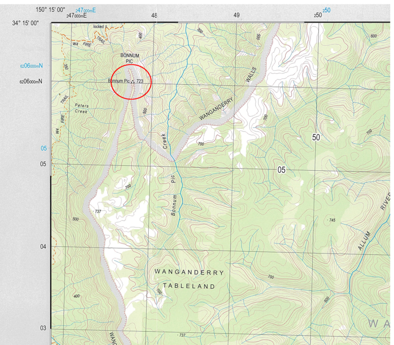
Care must be taken to quote all the zeros in the right place. In this example, the Northings have a zero at the front. The 6 figure grid reference is therefore 477060. Since the map is a new edition map and uses the MGA reference system, the six-digit grid reference is ‘Hilltop MGA-477060’.
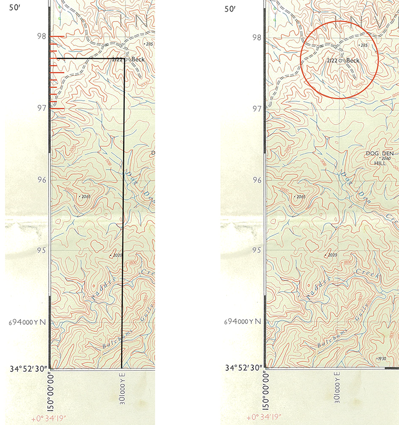
Example 3: Hill 2122. The hill lies on a grid line meaning that for a six-digit grid reference, the Easting has to include a zero at the end. Hence the six-digit grid reference of Hill 2122 is 010977. Since the map is an old map (‘1:31680 Caoura’) and uses the AMG reference system, the six-digit grid reference is ‘Caoura AMG-010977’.
Example 4: Hill 731.
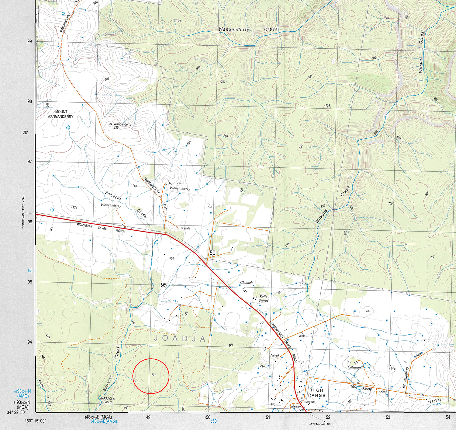
An 8-digit grid reference is even more accurate than a 6-digit one and has an accuracy of 10 m2. Supplying accuracy to the nearest 10 metres involves splitting up the grids into 100-tick increments.
Hill 731 has an eight-digit grid reference of 49029349. Since the map uses the MGA reference system, the eight-digit grid reference is ‘Hilltop MGA-49029349’.
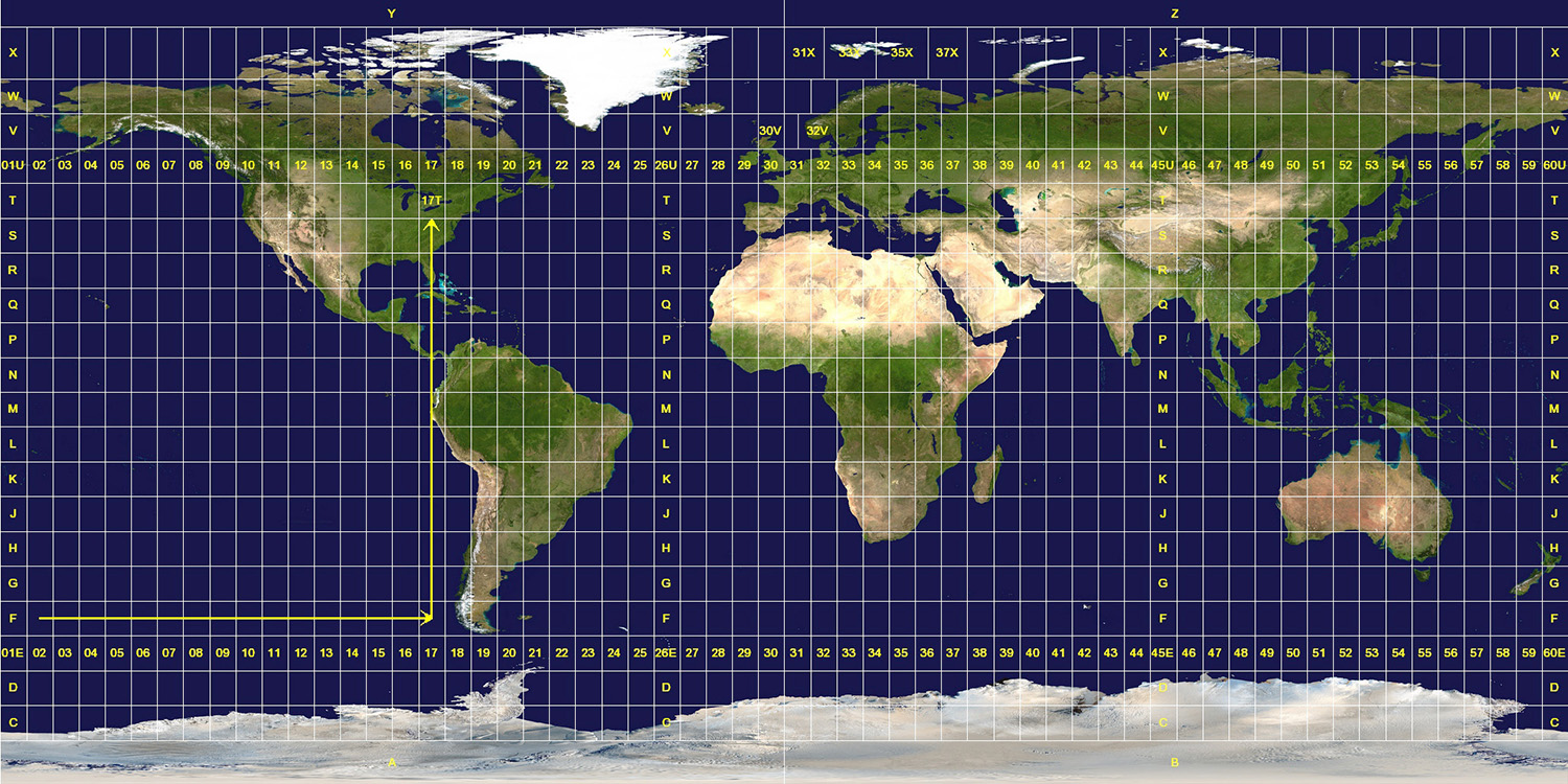
UTM zones: Identifying the region
UTM divides the earth into 60 zones each with 6 degrees of longitude, and 20 designators each with 8 degrees longitude.
 © Jan Krymmel, 26 Jan 2007 / Wikimedia Commons / CC-BY-SA-3.0
Australia falls between zones 50-56, and Sydney is in 56H.
A 6-digit grid coordinate system works well among bushwalkers to communicate points of interest and routes, and Bushwalkers use a shortcut to identify the region in question. They refer to the name of the map in question, a practical and quick solution for sharing information.
However, on a global scale, there would be many identically-numbered grid locations unless the specific UTM zone is also reported, along with a context for the Easting and Northing lines.
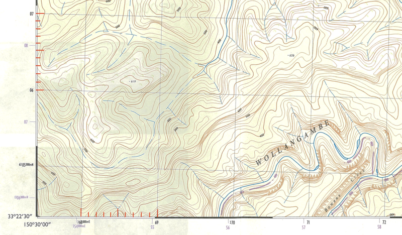
In the corner of all maps, the Eastings and Northings are given additional small numbers before the main ones that identify the lines.
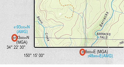
While the small numbers aren’t usually quoted by bushwalkers for six- or eight-digit grid references, they will appear on a GPS reading. GPS Eastings and Northings always include an accuracy down to the nearest metre. Hence for every square kilometre, the accuracy has to be to 3 digits for Eastings and Northings, something that is hard to do when reading off a map, but if given these grid coordinates, it’s possible to plot accurately.
Hence, the full coordinates of Hill 731 are Zone 56H, 0269210mE, 6316890mN. This is the same eight-digit grid calculated in example 4 above in orange.