
The whole length of the Great River Walk is planned, but most of the plan needs yet to be executed. For the time being, the following sections of the walk are marked and ready for walking. As new sections are opened, we will add them to the list below.
This 8km section of GRW is mostly the very popular ‘Bridge to Bridge’ circuit walk. From here you have great open views over the Nepean River and the Blue Mountains in the background. There are many opportunities to stop on the way and enjoy a break at viewing platforms or picnic spots. If you have small children, they will enjoy a break at one of the playgrounds. And if you’re hungry, several restaurants and cafés are along the way.
Image: Sudanaga05, CC BY-SA 4.0
 Overview of each section
This route can be either walked or cycled. It starts on the left bank (west side) of the Hawkesbury River at Lower Portland and proceeds north along Greens Road. Right away we cross the bridge across the Colo River, the most spectacular tributary of the Hawkesbury. It starts between Lithgow and Mudgee, and to reach the Hawkesbury, it carves the longest and one of the deepest gorges in Australia through uninhabited wild mountainous country. Moving along Greens Road we stay right on the bank of the river with views along the magnificent Liverpool Reach. Every stretch of the river is called a reach, and the further downstream we go, the higher and more rugged are the hills.
We pass through the old resort “Una Voce” after 2km and eventually arrive at a delightful glen at the 5km mark, an isolated pocket of pasture where we cross Greens Creek. Suddenly, the road leaves the river bank and steeply climbs onto the ridges on tight switchbacks until the main ridge is reached, with views north towards Yengo National Park and the wilderness country towards the Hunter Valley.
We are now on the Bicentennial Road, first passing Upper Half Moon Road (7.5 km from the Colo bridge), and then Chaseling Road South, 2km further on, both leading back down to the river. We also go under one of the main power lines, feeding electricity to Sydney from the Hunter Valley power stations. After 4km following the ridges, the Webbs Creek Valley comes into view to the north, and the road then descends back to river level as the Bicentennial Road meets Chaseling Road North, 4km after passing Chaselings Road South.
From here, we follow the river again towards Webbs Creek ferry crossing that takes us across the river. It’s a free trip, as are all the vehicular ferries on the Hawkesbury. ENTER On the other side, we arrive at the village of Wisemans Ferry. It is the only town on the route, and has shops, restaurants and a haunted pub, the Wisemans Inn, where accommodation is available if you don’t mind being haunted.
The next section of the walk begins by heading north along the Old Northern Road to the Wisemans Ferry, crossing back to the left bank of the river. Turning left onto Settlers Road, we cross the Tomas James Bridge, the oldest in-use bridge on mainland Australia. Then, we enter Dharug National Park at the gate 600m from the ferry.
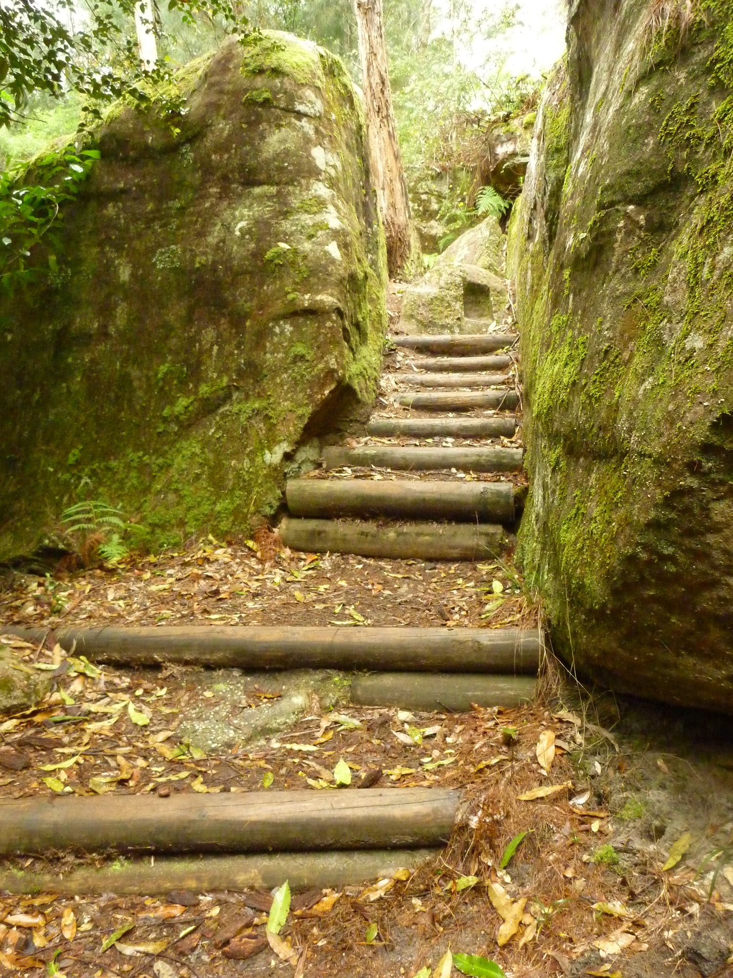
From here, we start climbing on the Great Old North Road, the original convict-built road providing direct access to the Hunter Valley for the first time from Sydney, then less than 40 years old. This road, built in the 1820s, is in a remarkable state of preservation with its imposing culverts, embankments and cuttings. It is amongst the best examples of convict road building in Australia. We pass Hangmans Rock and finally gain the ridge top at Devines Hill, just over 2km from the gate. This is all listed as World Heritage. From the top, Finches trail goes off on the right, being the original way up from the river.
The road now follows a complex network of sandstone ridges that divides the Macdonald River on the left with smaller creeks on the right. The views on either side are impressive as we head northeast for 9km before passing the Western Commission Road, which follows the power lines from the river. Just a kilometer later we arrive at a Buddhist monastery. You are welcome to visit and chat with the monks about their retreat. Then a kilometre later, the 10 Mile Hollow Camping area is reached, where there is a toilet and sometimes water in the nearby tank.
Here the Great Old North Road continues north. Just 2km up this track is Clares Bridge, built in 1830. It is the second oldest bridge on the Australian mainland after Thomas James Bridge at the beginning of this road, but unlike Thomas James, it is no longer in use. It is a massive structure, evidence of the skill of the convict work gangs.
Turning right, we are now on Simpsons Track, the original road from Sydney to the Central Coast. It heads east and, after 2km, drops off the plateau into the narrow valley, passing Simpsons Cave, a prominent sandstone outcrop next to the road. As we descend, the ground becomes damper and cooler, ideal conditions to support a gallery rainforest typical of Sydney’s sandstone country. Here, prominent rainforest trees such as Turpentine (Syncarpia Glomerifera) and Coachwood (Ceratopetalum Apetalum) are common.
So after following 10 Mile Hollow Creek from the camping area in 5km, we reach the Mangrove Creeks flats on one of the Hawkesbury’s significant tributaries.
At the road junction, we turn right and head south following the creek’s right bank, and in 2km, reach Mangrove Weir, part of the water catchment for the Central Coast. Observe the “No Trespassing “ signs here, designed to protect the water catchment, and stay on Simpsons Track heading south.
We are moving through a delightful and rather remote valley now, heading back to the Hawkesbury River. As we pass our first property, the road name changes to Oystershell Road at an opened gate. The landscape changes to a more settled farming country. This is amongst the oldest farming countries in Australia. It acted as a food bowl for the fledgling settlement in Sydney as early as 1794, as no fertile soil for growing crops could be found on Sydney Harbour.
On our way south we cross several creeks with funny names: Screech Owl Creek, Birdseye Creek and Sugee Bag Creek. The latter name may come from smuggling activities in the early 19th century.
Again, we are moving through an impressive valley surrounded by high sandstone hills. The end of the stage is reached at Mangrove Bridge, 10.5 km from the weir where Oystershell Road meets the busy Wisemans Ferry Road and 6km north of the charming old river town of Spencer and the end of the stage.
1. Lower Portland Ferry to Wisemans Ferry, 5-8 hrs, 16.9 km
2. Wisemans Ferry to Sugee Bag Creek, 2-3 days, 83.5 km
3. Sugee Bag Creek to Mangrove Bridge, 2-3 hrs, 6.6 km
Mangrove Bridge to Lower Portland
This route can be walked or cycled, consisting of back roads and fire trails. It starts where Oystershell Road begins next to the bridge across Mangrove Creek, 6km north of Spencer. The road is sealed for the first 4km and heads north along Mangrove Creek’s right bank (looking downstream) through a pleasant farming country. Mangroves line the creek bank as it is a tidal saltwater estuary in this section. It is the common grey mangrove (Avicennia Marinara), seen everywhere on the East Coast. The farming country here is amongst the oldest in Australia, as it was the nearest accessible fertile land for the new colony in Sydney Cove. The very first European farmers may have established here as early as 1794.
As you head north, a number of creeks are crossed, draining off the Dharug National Park to the west. Some have unusual names, such as Screech Owl Creek, Birdseye Creek, and Sugee Bag Creek, whose origins have to do with smuggling activities in the early 19th century.
A kilometer after leaving the sealed road the Eastern Commission Fire Trail comes in on the left. This trail follows the high-tension power lines all the way to the river at Sentry Box Reach. After crossing Sugee Bag Creek, the trail stays close to the river, which is still tidal at this point. An open gate is passed 1.5km past Sugee Bag, and then the last property on the right before arriving near the Mangrove Weir, part of the drinking water infrastructure for the Central Coast. There are “No Trespassing” signs here to ensure the water catchment around the weir remains as pristine as possible. Please observe them.
A track junction is reached in 2km where we turn left to follow Simpsons Track to the west. The road straight on is 10 Mile Hollow Road and leads to Dubbo Gully and the old Fairview Homestead. Our trail heads west and follows the narrow valley of 10 Mile Hollow Creek, where we enter Dharug National Park. This is a historic road as it was the first road access from Sydney to the Central Coast built by convicts in the 1820s. The vegetation changes from open grassland to undisturbed bushland with an open forest on the ridges and a gallery rainforest along the creek. The wetter and cooler creek banks support rainforest trees like Turpentine (Syncarpia Glomerifera) and Coachwood (Ceratopetalum Apetalum).
The trail rises steadily till it reaches the plateau at 300m altitude. Near the top of the hill, we pass Simpsons Cave, one of the Hawkesbury Sandstone outcrops. Simpson himself was the leader of convict construction gangs.
Soon, 10 Mile Hollow is reached, and the campgrounds. There is a toilet here, and sometimes water is in the nearby tank.
From there, the trail joins the Old Great North Road south and back towards the river. This is the original road north to the Hunter Valley from Sydney, built by convicts at the same time as Simpsons Track. The impressive remains of Clair’s Bridge are just 2km north from here along the Old Great North Road. It is the second oldest bridge on the Australian mainland.
There is a sense of remoteness here as we progress south and pass a Buddhist monastery, where travellers are welcome to visit and chat to the monks who live there.
Then follows several kilometres of trail, following the complex network of ridges, passing the junction with the Western Commission trail after 3km from the campground, then another 9km to Finch’s Track. The National Parks have installed many signs along the way to provide information about the history of the area.
Finch’s Track is reached at Devines Hill, the original way off the plateau back down to the river. But we follow the Old Great North Road downhill, passing many impressive convict-built embankments in a remarkable piece of early 19th-century engineering, all in an amazing state of preservation. We pass Hangmans Rock and continue to the exit of the national park and Settlers Road with Thomas James Bridge, the oldest still-in-use bridge on the Australian mainland. This section of the trail is a World Heritage site.
Then, in a few hundred metres, we reach the Wisemans Ferry crossing and cross the river on the vehicular ferry. It’s a free trip. On the way across, looking to the right, you can see the mouth of the Macdonald River, one of Hawkesbury’s largest tributaries that flows from deep inside Wollemi National Park, which is one of the biggest wilderness areas in NSW.
On the other (south) side, there is a park, toilets and a café, and just up the road, you are in the only township of this Great River Walk stage, at Wisemans Ferry. The pub, the old Wisemans Inn, is said to be haunted, but if you don’t mind that, the pub offers accommodation. There are also restaurants and a grocery shop in town.
Continuing on, we go the short distance north along River Road, past the junction with the Old Northern Road to the Webbs Creek Ferry, to take us back to the other side of the river. The trail now heads south on the river’s left bank. We pass Webbs Creek Road junction and continue of Chaseling Road North to the beginning of Bicentennial Road, barely 1km from the Webbs Creek ferry. Just beyond this junction is the Del Rio Resort, where camping and other accommodation is available right on the river shoreline at Bathurst Reach.
Continuing on, we ascend to the ridges again, passing Chaseling Road South, passing under power lines and then passing Upper Half Moon Reach Road 6.5km after the start of Bicentennial Road. Along these ridges, the river is over 100m below us on one side of the road, and the view north extends into the wilderness country with some distant peaks on the opposite side that are in Yengo National Park.
We then suddenly dive off the ridges in a dramatic switchback, bringing the trail back to the river bank again in a very pretty grove of trees and farming country as we cross Greens Creek on Greens Road. We now follow Liverpool Reach to the west.
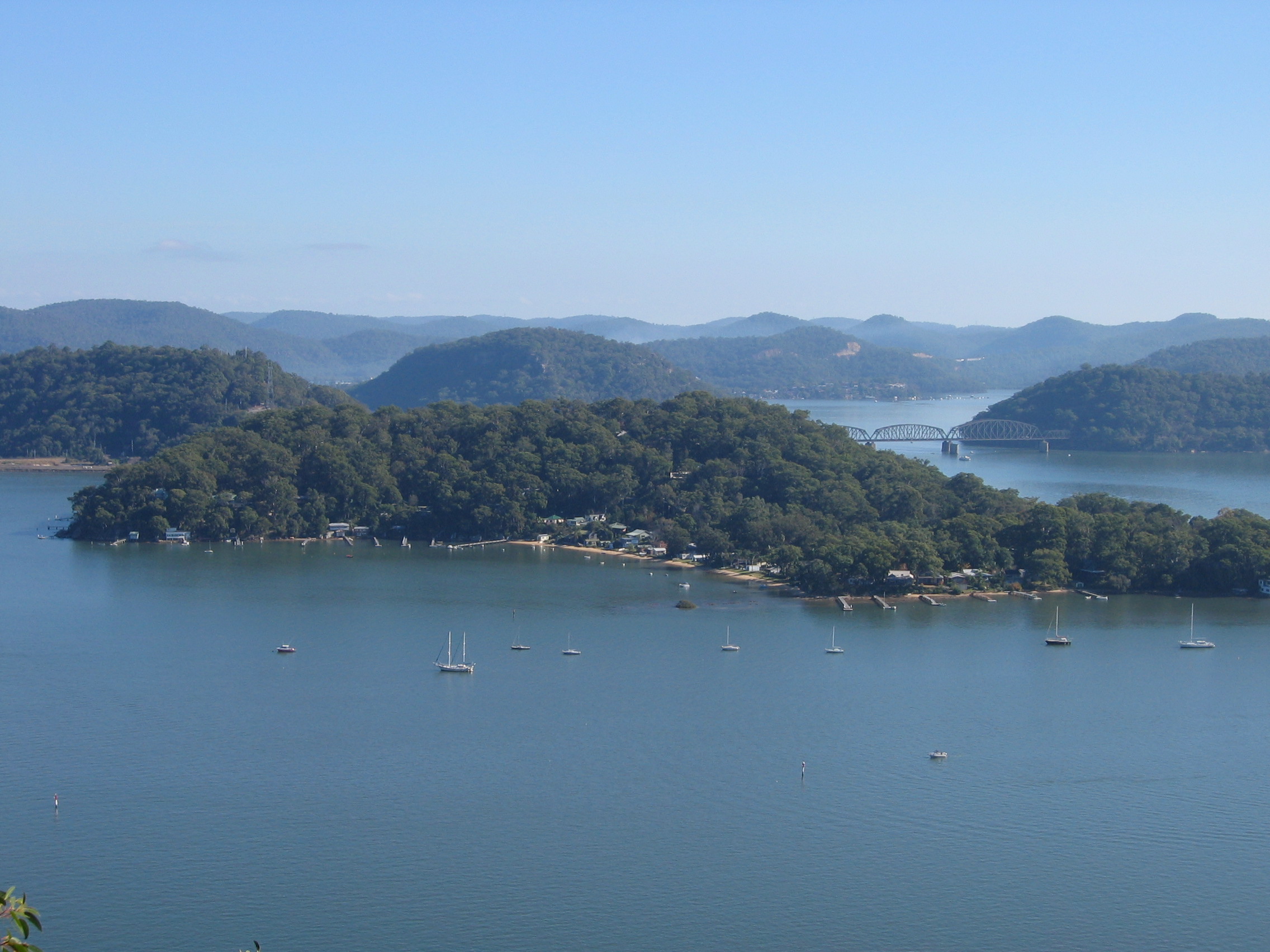
The Hawkesbury River is at its scenic finest in these reaches as the best and longest estuary on the Australian east coast. We are 80km from the sea and the river is still deep, navigable and tidal cutting through high forested hills all around.
After passing through the old Una Voce resort and crossing the Wheelbarrow Ridge Road, we finally come to the bridge over the most spectacular tributary of all, the Colo River, 7km after passing Upper Half Moon Reach Road. Here is the mouth as it joins the Hawkesbury, but upstream, it carves the longest and one of the deepest gorges in the country.
On the other side of the bridge, we arrive at Lower Portland and the end of the stage. Here is another car ferry, free again, with a café on the other side as a fitting end to an amazing walk.
 Preparation