| Turn map |
Directions & comments |
 x x |
(0 km) At the intersection of Old Great North Road & Settlers Road Start heading along Old Great North Road (a vehicle track).
 (0 km) After 20 m head through/around the gate.
 (0 km) Then find the "Old Great North Road" (on your left).
 (0 km) After another 25 m pass the "1 Welcome" (on your right).
 (0.1 km) After another 30 m pass the "Indigenous outline" (5 m on your left).
(0.1 km) After another 50 m pass the artwork (on your left).
(0.2 km) After another 50 m pass the "Australian convict sites" (on your left).
(0.2 km) After another 40 m pass the "Why Devines Hill?" (5 m on your left).
(0.3 km) After another 55 m pass the "3 Culvert and table drain" (5 m on your left).
(0.5 km) After another 215 m pass the "4 The large rock cutting" (on your left). |
 x x |
(1.1 km) After another 600 m (from the Old Great North Road) continue straight, to head along Old Great North Road.
(1.1 km) After another 10 m find the "Hangmans Rock" (on your right). |
 x x |
(1.4 km) After another 345 m (from the Old Great North Road) continue straight, to head along Old Great North Road.
(1.8 km) After another 360 m head through/around the gate. |
 x x |
(1.8 km) At the intersection of Old Great North Road & Shepherds Gully Road veer right, to head along Old Great North Road.
(1.9 km) After another 90 m find the "Devines Hill" (on your left). |
 x x |
(2.2 km) After another 330 m (at the intersection of Old Great North Road & Finchs Line) continue straight, to head along Old Great North Road. |
 x x |
(4.1 km) After another 1.9 km (from the Old Great North Road) continue straight, to head along Old Great North Road. |
 x x |
(5.1 km) After another 980 m (from the Old Great North Road) continue straight, to head along Old Great North Road. |
 x x |
(5.4 km) After another 345 m (from the Old Great North Road) continue straight, to head along Old Great North Road. |
 x x |
(11.8 km) After another 6.3 km (at the intersection of Old Great North Road & Western Commission Track) continue straight, to head along Old Great North Road. |
 x x |
(12.9 km) After another 1.1 km (at the intersection of Old Great North Road & Eight Mile Trail) veer right, to head along Old Great North Road. |
 x x |
(13.6 km) After another 790 m (at the intersection of Old Great North Road & Wat Loop Trail) continue straight, to head along Old Great North Road.
 (15 km) After another 1.4 km find the "Wat Buddha Dhamma" (15 m on your left).
 (15.6 km) After another 600 m come to the "Ten Mile Hollow" (45 m on your right). This is a free campsite. |
 x x |
(15.6 km) At the intersection of Old Great North Road & Simpsons Track continue straight, to head along Old Great North Road.
 (15.6 km) After another 45 m pass the toilet (75 m on your right).
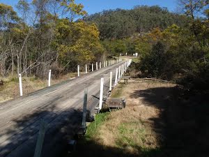
 (15.7 km) After another 50 m cross the bridge (about 7 m long)
(15.7 km) After another 7 m head through/around the gate. |
 x x |
(16.7 km) After another 1 km (at the intersection of Old Great North Road & Old North Road) continue straight (a walking track).
(16.8 km) After another 60 m find the "Clares Bridge" (6 m on your right). |
 x x |
(16.8 km) At the intersection of Old Great North Road & Old North Road veer left, to head along Old Great North Road (a vehicle track). |
 x x |
(17.3 km) After another 500 m (at the intersection of Old Great North Road & Wat Loop Trail) continue straight, to head along Old Great North Road. |
 x x |
(17.6 km) After another 270 m (at the intersection of Donnys Track & Old Great North Road) continue straight, to head along Donnys Track. |
 x x |
(18.9 km) After another 1.3 km (from the Donnys Track) continue straight, to head along Donnys Track.
 (21.4 km) After another 2.6 km find the "Donny's View" (10 m on your left). |
: An optional side trip to Fairview Homestead.